Showing posts with label Maps. Show all posts

Friday, December 27, 2013

FTM2014 - Resolving Place Name Video - a User Comment

As part of this blog, I have links to various training and other resources about Family Tree Maker. I was looking at some of those training videos to see if there is any information that hasn't been covered in those videos that I might include here.

I was watching this one, by The Barefoot Genealogist, Crista Cowan, on Family Tree Maker 2012 - Places and want to make a comment or two about a term that she used. The term was Description as it relates to the Place Name field. This item plays a role when exporting information between genealogy database management programs, like Family Tree Maker, to another genealogy program. We use the term GEDCOM. The format is a basic plain text file to share our research.

Facts and Events that take place for an individual is usually defined by a Date, a Place, and a Description field. In FTM2014 and other genealogy programs we can define these facts picking and choosing which of these items we want to include for that fact or event. Since I am talking specifically about FTM2014, I will use the term FACT.

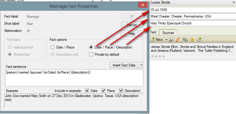
Many of our Facts contain all three fields. For example, a Marriage Fact is a Shared Fact between two people. Normally we would record the Date that the Marriage took place, and Where it took place, meaning location. But where do you put the name of the Church. Burials, the name of the Cemetery, the name of a school, etc. Until recently, the Description field was where we put that information. As long as we were consistent we could pull reports grouped by the Place Name, and adding the Description field, we could group or sort to include the Description field.

Here is an example of how I used to enter this information.


It has the Date, the location and the name of the Church as it should.

If I were to export this file to a GEDCOM, here is how it would look:

1 MARR Holy Trinity Episcopal Church
2 DATE 15 JUL 1939
2 PLAC West Chester, Chester, Pennsylvania, USA
Notice that the Description field is at the GEDCOM "Tag" level. (I won't go into the details of a GEDCOM file, nor Tags). The import of this file into another program should be these three pieces of information as seen in FTM2014, but many times it does not. In this example, the "Description" field may be out of place for the "other" program.

The Video showed how FTM2012 works in this type of situation. The issue is resolving Place Names. You will notice the ICON to the right of Pennsylvania with the Question Mark, which indicates that the Place Name needs to be resolved.

When I look at the Marriage Fact, in this case I have two, one with the Church name, and the first entry without the Church name, it is clear where the marriage took place.


Now, I want to resolve the place name. I click on that ICON and a new window opens up.


When I click on Search, all FTM2014 wants to do is to Add USA. The Video goes into great detail about all of this. So far, so good.

I then click Replace and FTM2014 changes West Chester, Chester, Pennsylvania to West Chester, Chester, Pennsylvania, USA


As I mentioned, with each Fact, we have choices to make, as to what is displayed or used for that fact. We change or control that by selecting the Fact and in the Options Pull down menu, we select Properties.


There are the three fields, Date / Place / Description. That is the Marriage Fact Properties that I have selected for this Fact.

.
I have talked about the importance, to me, of the Mapping Feature. Using the resolved format, this marriage gets lost with the other 180 Facts that took place in West Chester. I want to see how many events took place at this church, or a Cemetery, or school, or address. FTM2014 is "happy" but I am not.


So far, I am in total agreement with what the Video shows. So, now how to get the events that took place at that Church?

The video would suggest that the Name of the Church be moved from the Description field to the Place Field.. The video used other examples, but we will end up doing the same thing for the same reasons. When I add the name of the Church, the Place Name is again Unresolved.


As before, the search would try to get rid of the name of the church, because it isn't a place, but FTM2012 and FTM2014 gave us a way to handle this situation for addresses, church names, cemetery names, and historical names.

Here is the issue, and it is only in the use of a word. The term used in the video, is that she moved that information to the Description field. The screen shows PLACE DETAIL, not place description.


As the video shows, using that up arrow to the Left of the name of the Church "moves" the name of the church to the Place DETAIL. I can't call it a field, because we can't see it as a field, but within FTM2012 and FTM2014 it is additional information for the name of the Place which now includes the Church Name.


I click on Replace and the next screen appears. It's an "are you sure" screen. We have choices, Change all instances or Change only this instance. I rarely would use the Change All option.


Returning to the Marriage Fact, the name of the Church is in the Place field and the Description field is Blank. But the Place Detail has the name of the Church in it.


Now, what happened to the Map? In the Places workspace, right column, I now see that I have a number of Events / Facts that took place at that Church. 6 people have Facts that took place at this Church.

The church is selected in the Left Panel, the pin shows it's approximate location and the Right Panel shows who had an event at that church


.

A closer look at the Right Panel:

The same steps are used for Cemeteries:


This cemetery has 39 people in my database who are buried there. With the map feature you can zoom in and really see what the cemetery looks like. I have pinpointed the location of some of the 39 people and where they are buried. If I were to share this with another researcher, we might save some walking around trying to find where someone is buried.

As was pointed out in the Video, I can back up to the City, West Chester, and see that I have 197 Facts that are linked to West Chester, including the Church, the Cemeteries, and addresses in my database.


Back to the point about Description, Place Detail, and GEDCOM.

1 MARR
2 DATE 15 JUL 1939
2 PLAC Holy Trinity Episcopal Church, West Chester, Chester, Pennsylvania, USA
My point is that I think the video should have used Place Detail and not Place Description. The Description would have been to the right of MARR.

_______________________________________________________________
Copyright © 2013 by H R Worthington

Monday, September 16, 2013

FTM2014 - Place Workspace - Unresolved Place Names

Regarding: FTM2014 - Place Name Importance

The issue was brought up about the ability to have one "button" to push, to resolve all of the Unresolved Place Names.  This is not a new feature, but I think it is important to spend a few minutes understanding the Resolve All command.

The Unresolved Place Names are very important when you want to use the Map Feature. I use this feature to see who had an event / fact in a specific location, mainly because the Place Name feature allows us to standardize the Place Names. This feature has us use the Location, (which might be a city), County, State, and Country format, without the use of the word County. Location might be a Township, but the word Township won't be in the place name.

I wrote about this earlier: Consistency Check Reminders part of the FTM2012 Places Workspace

There doesn't appear to be anything new in this area, but based on the comments about the Place Name Importance blog post, I thought I would review the Resolve All feature again.

The Place Workspace:

A review of the ICONs in the upper left of the Place Workspace shows down the Left Column all Place Names that are NOT Resolved. At the top of that Left Hand Panel are 4 ICONs.
  • Flat View - Turns the Flat View On or Off. I normally don't turn it off and have the Hierachy View on
  • Expand All - In the Place Names at the Country, State, County, local level all expanded
  • Collapse All - Turns the Expand All off
  • Resolve All 


Example of the Hierachy View on

Notice the Yellow in the Arizona box? That is a right pointing arrow. It's difficult to see on this screen capture, but can be seen on your display. That indicates that it can be expanded, like California is below and Los Angeles is below that. The other thing to notice is the Check Mark that has replaced the Question Mark (?) in the earlier graphic. That indicates that the Place Name has been resolved.


The Expand All, Collapse All will do just that for those countries where the Place Names have been resolved. In the screen capture above, I did NOT use the Expand All, I manually expanded USA, California and Los Angeles.

For this blog post, we are going to Resolve All.

Selecting the Resolve All ICON, the Back Up window will open. I STRONGLY Recommend that you take that option.


Clicked on YES which brought up the normal Back Up window. I take all of the options, with check marks in the lower Left side of the screen. AND I normally select my External Drive for the Location of the Back Up. For this purpose, I am left FTM2014 back up to the Default, My Documents / Family Tree Maker folder.


The Back Up is Processed as usual


And completed.


Clicking OK will bring up the Resolve All screen


This is a list of ALL of my Unresolved Place Names.

A little closer view of the top part of that screen


There are 5 places for Check Marks
  • Unrecognized Place Name
  • Suggested Place Name
  • Desc
  • Ignore
  • Other
From the Help Menu (F1) from that Resolve Place Name window we see:

Resolve All Place Names
Resolve All Place Names helps you correct location names that are not found in the Family Tree Maker database. You can correct the name so it is spelled correctly and in a consistent format throughout your tree file or have Family Tree Maker accept the place name as you entered it.
Family Tree Maker checks each place name against its database to determine if the location is known. If the name is not found, it is listed in the Resolve All Place Names dialog box. You have a number of options for handling each place name. The following table describes the options available in the Resolve All Place Names dialog box.
 Each of the 5 options are described there. I'll not post that here. Basically the Description means that the data may belong on the Place Name Description field, like the name of a cemetery; Ignore simply means to Ignore the Place Name warning.

The Suggested Place Name column is what Bing and Family Tree Maker "think" the place name should be.

In my case, I have used this feature in the FTM2012 Place Workspace blog posts.

But why do I still have Unresolved Place Names? Here are a couple of examples:
  • South River Monthly Meeting
  • Shewan, Baltimore, Maryland, USA
  • Sharston Hall, Manchester, England
  • Saint Georges Cemetery, Harford, Maryland, USA
  • Penndenny, Annapolis, Anne Arundel, Maryland, USA
  • All Hallows Parish, Anne Arundel, Maryland, USA
Each of the location names have been found in source material. Many are historical place names. All Hallows Parish, Anne Arundel, Maryland, USA being one of them. Pre-county times in Maryland. Shewan is a Property Name. The first entry is a Quaker Meeting Name. They aren't resolved because I haven't been able to research where those locations WERE and where they might be on today's map. I don't want to Ignore these place names, I want to research them, but haven't gotten them manually resolved. I work on them frequently.

The Map feature is very important to me, and I want it to be as accurate as possible.


_______________________________________________________________

Copyright © 2013 by H R Worthington

Friday, November 25, 2011

File Sharing and Brick Walls - Part 3 - Place Names

Continuing Clean Up of file. Again, this is for my purposes with no reflection on the person who sent me this file, but our common goal is to attempt to attach a brick wall.

Earlier, I addressed how to import a GEDCOM file, then how to address Unknown Names. Each of us needs to identify these unknown names as we each have them.

This next step is to deal with Place Names. For this example, at this point, Historical Place Names may not play a role in this brick wall. But, for me, based on some observations in this file, the use of the Map feature will be important. In the 1700's the travel between Dutchess County, New York, to Woodbridge, New Jersey, to Newton, Sussex County, New Jersey needs to be looked at. For me, at this point, the use of the Map feature is important. Who had an event (or Fact for Family Tree Maker) in the various locations will be important.

Going to the Places Workspace and looking down the Left Column is an ICON that indicates that that Place Name is not in the format that the Place Name Authority (PNA) of Family Tree Maker 'wants' or suggests. This ICON will appear any time a new Place is entered as seen in the upper right of this screen.


At the top of the Left Hand Panel is a Resolve All option (its in that green bar). Clicking on Resolve All will bring up a Chart of all of the Place Names that are not part of the Place Name Authority. However, it is NOT required that we accept or use the PNA. In this specific case, MOST, but not all suggestions will be accepted.

There are four columns. with out check marks. The first column indicates that the user accepts the suggested PNA name. If the list looks like the entry is really a Description, then the 2nd column can be used for that, and there are other choices.


There are several here that I will leave as Unresolved (those in blue). They appear to be valid place names, but at this point, I am just cleaning up the "easy ones". There others can be resolved later. At this point, it's data consistency that is important for me, for this project.


The Unresolved ICONs are still on the left, and they are the ones I chose not to resolve. What is important, at this point, is that I have a good look at who has a Fact that took place in Newton, Sussex County, New Jersey AND I can see where it is. There are zooming in and out which will be used later. But This gives me a good handle locations within this file.


Copyright © 2011 by H R Worthington

Friday, July 24, 2009

Source Citation Template - Group 10 - Publications - Books, CDs, Maps, Leaflets, and Videos

Continuing with the discussion on the use of the Source Citation Templates started

Source Citation Template - Source Group


This series of Blog posts will expand each of the Groups and show the various Categories that will appear on the Category menu. The list of Categories to select from. Each of these categories are referred to in Evidence Explained by Elizabeth Shown Mills

Group 10: Publications—Books, CDs, Maps, Leaflets, and Videos

Category: Print Publications
QuickCheck Model: Pages 646 - 653

Category: Electronic Publications
QuickCheck Model: Pages 654 - 657

Category: Image Copies
QuickCheck Model: Pages 658 - 661

Sunday, June 28, 2009

Family Tree Maker 2009 Map Feature Example

Continuing from the previous Blog, Library Visit - Family Tree Maker Version 2009 map feature offers some additional information. Clicking on the Places Tab, will take you to the Map Feature. In the Left Panel is that list of Place Names that are in this file. Since the family in the previous blog was located in Flemington, Hunterdon County, New Jersey, we can see 1, where it is, 2, and who had an entry in the file, referring to Flemington. In the Right Panel, where the names are listed, clicking on the "+" sign will expand what event / fact took place there.


Figure 165

There is the ability to change the Map based on a Location, to a Map based on an Individual. The down arrow will provide that option.


Figure 166

In this example, Hiram Deats is selected (1). A map will appear with some lines and ICONs, representing specific locations. The Right Panel (2) will indicate what event / fact took place when and where. To determine what event took place on a specific Place ICON will open a note with the details of that location and what event took place there.

Note, that the New Jersey, USA ICON is "in the water". It can be moved. But for this example, it would indicate a FACT that needs to be looked at in more detail.


Figure 167

Below is the Map showing the places where Hiram Deats is recorded in a FACT.

Posted by Picasa

Print Friendly